Descrizione
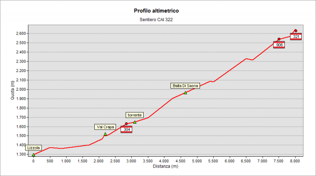
Start from Lizzola (1259 m) and take the forest road that goes up Bondione valley. After the first stretch of the valley - that is almost flat - the path climbs more steeply (pay attention at a short stretch of rocky plate equipped with chains) always on the left orographic side of the stream, up to the intersection with path n° 304 (1620 m – Central-Eastern Orobie Trail / Sentiero delle Orobie Centro-Orientali). Then you pass a steeper stretch that leads to “di Sasna” hut (1961 m) and “di Sasna” ponds. Continue through pastures, peat bogs, ponds and roche moutonnée reaching - at an altitude of 2316 m - the point where you cross the river that springs from Bondione lake and pass on the right side of the valley. Then you go up more steeply, reaching the head of the valley where you cross path n° 321 (about 2550 m) coming from Cerviera valley. You pass a last short stretch to go up to Bondione pass (about 2650 m). The path 321, in this section, climbs a little further to the left and also reaches Bondione pass. From such pass it is possible to climb, in about 30’, to “Pizzo dei Tre Confini” peak following a path bypassing the most difficult stretches of the ridge.
Topografia