Descrizione
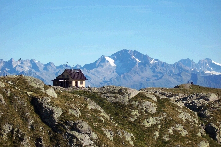
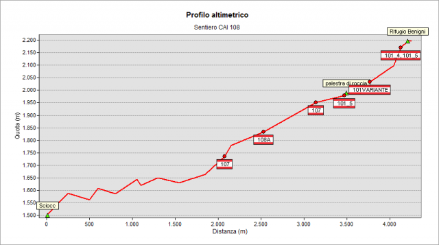
The path starts at Sciocc hut at height 1508 m, along the road that climbs from Cusio to Piani dell’ Avaro (parking place). After a steep stretch, the path follows flat westward, crosses a sparse forest and reaches Valletto hut (1782 m). Go on with some hairpin bends and, near electric pylons, cross the 107 path coming from Ornica. The path climbs with constant slope to reach the basin below Salmurano pass. Crossroad on the left with the 108A path leading, with an easier but longer way, to Rifugio Benigni. Go ahead on 108 path and, after a short stretch, leave on the right the 107 path leading to Salmurano pass. Continue along the base of the cliff and climb along the steep "canal", not difficult if you follow carefully the marked path with the due attention. You reach a basin just below the Rifugio, not yet in view. Climb the last stretch to cross the path 101 coming from Rifugio Grassi and, following the path, reach Rifugio Benigni (2222 m), in a magnificent place with view of Rhaetian Alps
Per vedere tutto il percorso con Google Street View Trekker clicca qui
Topografia
Sentieri collegati
Documentazione
Note
E' utile segnalare che il transito per le auto oltre il Colle della Maddalena (è la strada per i Piani dell'Avaro, utilizzata anche per giungere all'inizio dei sentieri 108 e 109) è ora a pagamento: 2 € il permesso giornaliero. Indicazioni in loco e macchinetta distributrice dei ticket già prima del tratto a pagamento. (aggiornamento: 26 giugno 2016).