Descrizione
WARNING: Due to growth of vegetation is not always easy to follow the path, especially on the Valcanale slope. Pay attention, please! (August 2013).
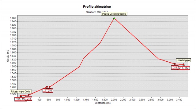
From the parking area (about 1600m) at the end of the road coming from Roncobello, get the Mezzeno huts on the carriage road and, just beyond the bridge, turn left. Climb through steep pastures and enter the valley leading to the Marogella pass (1873 m). Go downhill to the Valcanale valley, crossing a sparse forest. You get the crossroad with 216 path at the bottom of the valley, near a bridge (approx. 1460 m). For the last stretch the path is overlapped on 216 path, turn right (southward) and quickly you get the RifugioAlpe Corte (hut 1415 m).
Topografia
Sentieri collegati
Documentazione
Note
NOTE 1: To run on the municipal road Capovalle - Mezzeno you must pay a toll at the parking meter near Capovalle and show the receipt on the car cockpit. Frequent checks are carried out by local police. The parking meter gives no change and smallest coin accepted is 10 cents. Daily parking and transit toll is 2 € (2015).
NOTE 2: The Marogella Pass is located on the border line between the Orobie Pre-Alps and Bergamasche Alps: southward of it, there are Pre-Alps made by limestone rocks and mountains with light-gray appearance (in the area: Arera peak, Corna Piana, Valmora Peak, Fop Peak, etc.); northward there are the Alps made by siliceous rocks and mountains with dark colors (in the area: Salina Peak, Pradella Mopunt, Spondone Mount, Tre Pizzi, etc.).