Descrizione
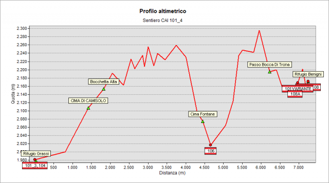
Start from Grassi Hut (1987 m) and follow the southern slopes of the Cima di Camisolo top. Continue following the panoramic “Pian delle Parole” ridge until reach the “bocchetta Alta” notch. Leave on your left the "del Caminetto" equipped path (which leads to the summit of "Pizzo dei Tre Signori" peak) to cross the steep southern slopes of the mountain along a mountainside path (known as "Sentiero dei Solivi" path). Once you have reached the “d’Inferno” valley, suddenly you will go down, until you cross path n° 106 and the torrent. On the opposite side, go up along an evident gully until to reach its summit. Continue eastward and follow the Giarolo crest until you reach the “Cima di Giarolo” top (2314 m); then go down to the “Bocca di Trona” pass. Now follow the flat track and reach - in just a few minutes - the next pass - the Piazzotti notch - placed between the “Cima di Piazzotti occidentale” top (“Cima di Val Pianella” top) and a more modest high ground belonging to the “Pizzo di Giacomo” peak group. Finally, walking along the steep grassy slopes, you arrive at the panoramic rocky plain where the Benigni Hut (2222 m) is located. Along the whole trail, it is possible to meet herds of steinbocks. The panorama is dominated by Mount Disgrazia and the jagged peaks of “Val Masino” valley. The Bernina group appears in the background.
Please note
On the geoportal, the long path n° 101 has been divided into seven parts: 101_1, 101_2, 101_3, 101_4, 101_5, 101_6, and 101_7, to better describe the different stages.
However, the signage on the ground up to the Tartano Pass will report only the number 101.
______________________________
_________________________________Topografia