Descrizione
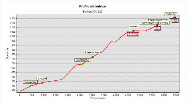
From Gazzaniga’s parish church you go up as far as S. Rocco’s small church. Then you venture into the valley up to Ruclisciù’s small church. You keep on walking up to Plaz valley, you reach a flat path and, turning right, you find a track that leads under Ganda’s field and then up to the church’s small square (where path n.522, n.520 and 538 meet). From Ganda’s church path n.522 and path n.521 overlap for a while and you follow the paved road towards the astronomical observatory of the Orobic Pre-Alps. From here you start going up again and the road becomes unpaved. You get then to a crossroad with two paths – one takes you to Monte Poieto and the other one takes you to Ca de Spì. You follow this last sign turning right and the path gets flat as far as the destination. Near Ca de Spì path n.523 and path n.525 intersect.
translated from the class 2D del corso "Tecnico dei servizi di animazione turistico-sportiva e del tempo libero" di Clusone
Topografia