Descrizione
Path A. CASLINI (or partisan’s path)
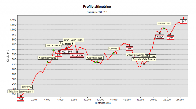
If you come from Bastia Mountain (path 509), in Tribulina di Gavarno square you join Misma Mountain road and you go up toward the hills. You walk among private villas located in a green environment made of vineyards and woods. The dirt track goes on the slope covered by a copse wood (hornbeams, flowering ashes and oaks). From here, you have a beautiful view over Gavarno’s hills that encircle the plane.
When you get to the last hairpin turn, a path goes westward to the hill’s rib covered by pastures and grasslands. From here, you enjoy a wide view: on the right the lower Valcavallina and on the left Spersiglio’s Valley.
A little bit farther, when you reach Predale place by the ruins of an old bird-shooting hut, on your left winds the mule track that leads you to Spersiglio Alto’s farm holiday (junction with path 539). Going up along the crest walking in a poor pasture, you reach Monte Bastia’s saddle, where an old bird-shooting hut is located and from where you can watch on Valpredina, that is a WWF natural reserve. The paths goes on flat towards Santa Maria di Misma, that is an old parish church dated back to 1000 A.D. and restored in 1520. Inside this church you can see an Enas Talpino da Salmeggia’s canvas portraying St. Mary the Assumption, whose feast day is on the 15th August. The path keeps on as far as Costa di Misma, where it joins some other tracks coming on from Val Cavallina. Walking among some bird-shooting huts, you reach Predòlt – Prati Alti place, where a well-kept bird snare is located. Taking the path that goes down towards Valotella, in a few minutes you can reach Borai’s fountain. From Predòlt, passing through Fellongo’s wood, an easy unpaved road leads you to Casale, that is a small touristic village that overviews Lujo’s valley. You reach then the Colle Gallo’s country road by the fountain and you enter into Casale’s square. You keep on walking in the street in front of you and then you follow the path that, keeping upline the fencings, leads you to Pasolina’s spring in a short time. Keep on walking through a chestnut wood and you get to Pracc Molècc place by an abandoned nineteen-century votive chapel. Here you join path 512 and path 541. Keep right on the paved road, pass near a restaurant and keep on walking along Monte Altinello’s south slope. First you cross a copse wood and then wide fields, some of them still regularly sickled and full of little mountain cottages with a wide view over Val Cavallina. You follow then the path that goes down through the wood as far as the mule track that leads to Valle Rossa’s col and joins the road leading to Bianzano. By the fountain, you go over the guardrail and you walk along the road for a short stretch. You cross Rottosa creek and you follow the path on your link. You shortly reach “Cà Caglioni”, where the path turns links running along the creek on its right side. Walking easily up you reach a spring where the path turns abruptly right and you keep on walking as far as “Ca Prel” place. You walk up for a short stretch on a grassy ground and you reach a pastoral road. Then you turn left and you keep on walking on a very scenic track in the Orobic Pre-Alps as far as “la Mònga” place. You keep on as far as Tribulino della Forcella first and then to Monticelli, where you join path 547 coming from Gandino and pointing to Malgalonga.
translated from the class 2D del corso "Tecnico dei servizi di animazione turistico-sportiva e del tempo libero" di Clusone
Topografia