Descrizione
It is a track not very used. It represents an interesting and valid alternative to the classic access ways to the Gemelli Lakes area.
Some years ago, this path has been named also the "il Sentiero del Partigiano"(Partisan’s Path).
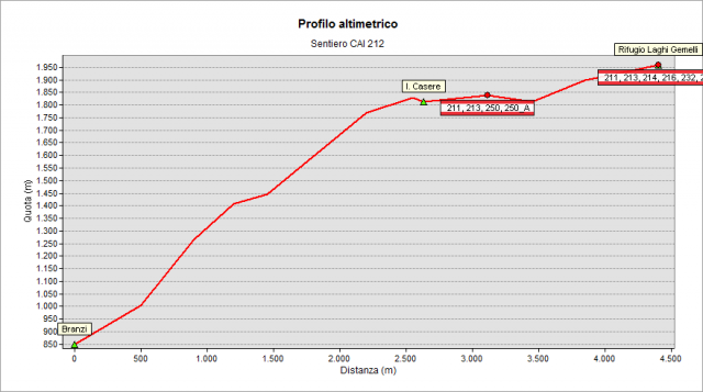
On the left orographic slope of the Brembo Valley, under the “dell'Orto” Peak, the trail climbs in the woods till Pian Casere Dam and, at the Enel dam watchers’ house, meets the 211 path following to Rifugio Laghi Gemelli.
The trail starts from Cagnoli Street in Branzi village (approx. 825 m), near the football ground, where there is a convenient public parking area; an alternative access to the trail is near the Borlèggia waterfall (approx. 840m) near the parking area of Monaci Street. Both paths join after around 15 minutes of walk from the start, at a height of 1040 m. Short ahead, at 1110 m, the path crosses a small road called “strada piana” (or flat path - not cared for by CAI and linking Carona to Roncobello); due to avalanche effect and clear cuts for tree disease no vegetation is surrounding the next stretch, so you can enjoy a wide view till the recently planted trees will give back the original appearance to the wood.
At a height of about 1,400 m you reach a place called “i Grassi”, where there are some municipal huts where shepherds and herders pause during the transhumance through the mountains; following the path you reach Pian Casere dam (1815 m): here the forest ends and begins the typical local high mountain landscape.
After walking few hundred meters more, near the ENEL watchers’ house, you meet the path 211 and from here you go on the common track reaching the Rifugio Laghi Gemelli (Hut) (1968 m)
Topografia
Sentieri collegati
Documentazione
Note
A quota 1680 nei pressi del sentiero si può osservare il monumento funebre dell'ing. Rho, morto (probabilmente per infortunio nel corso della costruzione della diga) nel 1923, eretto dalla "Società Forze Idrauliche Alto Brembo".