Descrizione
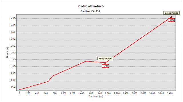
Coming from Ponte Nossa, reached Oneta village, follow on the main road and, after 200 m beyond the town hall, turn right on Papa Giovanni XXIII street (see CAI signpost) to “Plazza di Oneta” hamlet (923 m) Park your car in the hamlet. Following CAI signpost directions, enter the small settlement and, keeping the left, go downhill on a dirt road to a farmer’s hut. At the right of it, the 239 path starts. After about half an hour of walk you reach the crossroad with the path leading to “Colle di Zambla” (Zambla Pass - see the signpost). Following the directions of signpost, climb gently to right to a clearing with a pond: very panoramic view. After a last effort and in few minutes, you get Rifugio. Alpe Grem (1198 m, about 50 minutes after start). From Rifugio, climb, in few minutes, to a dirt road leading to Baita Bassa di Grem(1238 m) (Grem lower hut). You reach it in about 10 minutes. Following the signposts, turn right on the dirt road. In the area there are some old abandoned mines for calamine (zinc ore). Shortly after an old mining building, the dirt road enters the wide pastures of Grem Mount. Now follow the path climbing right, guided by the signs on rock cairns, pass a pond for livestock drinking and reach the crossroad with 223 path coming from “Colle di Zambla” (Zambla Pass) (1457 m, around 1:40 h after start). Just below is visible the “Baita di mezzo di Grem”(middle Hut of Grem).
From “Plazza of Oneta” to “Baita bassa di Grem”, the path is overlapped on “Sentiero Etno-naturalistico Baita Alpe Grem” (Grem Alp Hut Ethno-Naturalistic Path) made by the municipal administrations of Gorno and Oneta. Along this path there are boards explaining the mines activities, the pond and its ecosystem, the woods and the pastures. The boards was made by the pupils of primary schools of the two villages with the help various associations including the “Val del Riso” branch of CAI .
Topografia