Descrizione
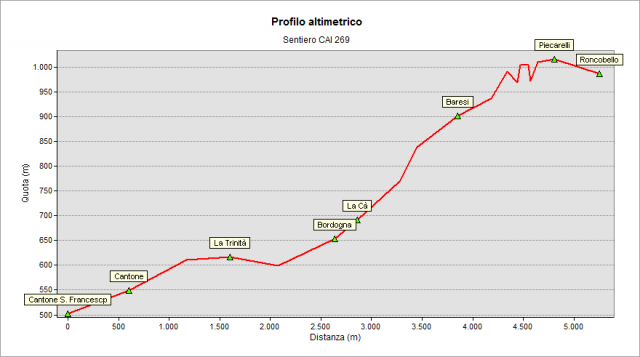
Before 1882 the access to Valsecca valley was via the mule track still existing from Lenna to Bordogna, Baresi and Roncobello. This route, up to the mid-1800s, was also used to access the Fondra Valley through a deviation, track still available, starting from Forcella di Bordogna hamlet.in 1882, a bridge on Brembo river was built in Bernigolo, to connect the Valsecca Valley new car road and the one leading to Fondra Valley. The latter road was built in the first half of 19th century, when Lombardy was still ruled by Austrian Empire. In 1927 a new bridge, still used in our days, was built exactly above the former one. The ancient mule track called "de la Paghèra" (in the fir forest) has been used for many centuries and still today we use it, re-discovering many signs of local people's activities. The path starts from the Ponte Chiarello (Chiarello Bridge , in local dialect :Put Ciarèl), downstream the dam forming the Moio in Lenna territory. Leave the road leading to “Cantone San Francesco” (St. Francis neighborhood) to reach a clearing on the right. Before entering the old mule track (on the left) it is worth to go for a short stretch downhill to see the "Acqui Spring" small fountain built in 1941 by the soldiers of the Acqui Division during their stay for military exercises. The mule track passes above Cantone Santa Maria ( St. Mary neighborhood in dialect called Pòspiòda) and reaches the S.S. Trinità (Holy Trinity), historic sanctuary between the villages of Lenna and Roncobello, one of the many signs of religious devotion that accompanied and comforted the hard hicking. On the opposite bank of the river Brembo there is the Bordogna hydraulic power plant, where the river flows into a spectacular canyon dug by the water in the millennia. Nearby there is an old oven for limestone cooking. The area of S.S. Trinità has special naturalistic characteristics because the temperature is significantly lower than in the surrounding areas. This situation allows the presence plants of high altitude like rhododendron and pinguicula (alpine butterwort). The lower temperatures are generated by the cold air flowing down from higher altitudes through the gaps among the rough debris of the decayed above rocks. The air stream get out at a temperature some degrees lower than the local environment cooling down this narrow area. Follow the path passing near "Cà Brùsada"(burnt hut) and reach the bridge over the Valsecca creek. Note in this palce the different colors and composition of the rocks and stones on the banks of the creek. Southward you see the light gray limestone of the Pre-Alps ; northward the metamorphic rocks (called verrucano) of the Orobian Alps. Beyond the bridge - remains of an old mill - and the Bordogna cemetery, enter the village through the oldest and most characteristic part: porches, church and ancient bell tower, votive chapel for plague (1630) and Tower worth a visit. (50 min). In front of the facade of the church, a stairway leads to the "la Cà" hamlet and then to Forcella neighborhood, with the church of S. Giovanni Battista (St. John the Baptist) that preserves frescoes of the 1400. On the east side of the church the milestone (addressing to Fondra Valley ) and on the façade of a village house, the memorial plate of Cardinale Cavagnis. The penstock from the basin of Baresi to the hydraulic power plant of Bordogna characterizes the landscape. The mule track follows steeply (called "the Ria di spì" meaning “Thorns’ Slope”) to Baresi and get the church yard, great panoramic point (45 min). Go beyond the church, on the same mule track, to the square with the old town hall. Old buildings are an example of local mountain architecture with the stables near the houses were used in winter as warm place for manual works and for the common life of the inhabitants. From here, you can quickly visit an ancient well ("pòss" in dialect), nice and interesting to see for its construction technique. Go back to the square and then to the "Caaléra" (horses' passage) with the ancient milestone and the notary's house. Have a look at Mount Menna and the valley below to note its geological features. The mule track continues to S. Rocco hamlet (St. Roch) along the hillside through meadows partially invaded by the forest. Beyond S. Rocco the path goes slightly downhill to Roncobello village. Reach the church yard crossing the historic center of the village
Topografia