Descrizione
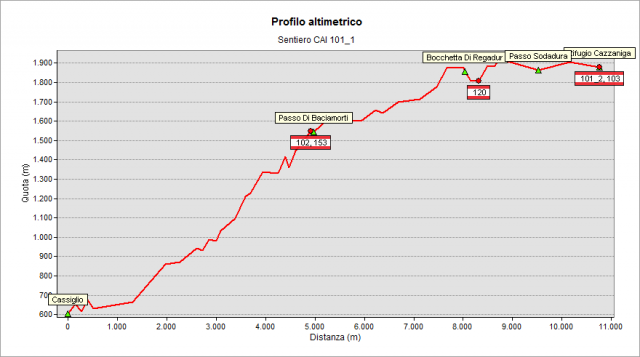
Start from Cassiglio (604 m) and follow the road that leads to the small basin of the Cassiglio lake, which is passed along its right shore (hydrographic). Continue along the dirt track until a junction where you take the graded path on the left, which soon enters the woods. Alternating steep and sometimes flat stretches, you reach the rocky “Canale Chignolo” gully, which you cross. Continue the ascent and climb towards the upper part of Cassiglio valley, arriving just below the north-western ribs of the Mount Venturosa, where the track still crosses a couple of gullies. Finally, coming out of the woods, you arrive to the grassy Baciamorti Pass (1541 m - intersection with path n° 153 coming from “Val Taleggio” valley and with path n° 102). You go up along the grassy coast of the “Pizzo Baciamorti” peak, until you reach Rudera hut (1620 m). Then continue by a moderate ascent between pastures and plains placed along the slopes of Mount Aralalta. Further, the path climbs by some steep hairpin bends to the Cabretondo hut (1882 m). Then it reaches the Regadur notch (1853 m) and a detour - on the left - towards the Gherardi Hut (path n° 120). Beyond such notch, you climb slightly up to the Regina hut and to the Sodadura pass and then - on flat terrain - continue westwards, bypassing the northern slopes of Mount Sodadura. After passing another notch, enter the basin where the Cazzaniga-Merlini Hut is located, which is quickly reached. There, you can enjoy a beautiful view of the Lecco mountains (Grignone, Grignetta, Resegone, Zuccone dei Campelli, Monte Due Mani, Pizzo dei Tre Signori) and of the upper “val Brembana” valley. On clear days, you can see Mount Rosa, the Matterhorn and the sharped pyramid of the Finsteraarhorn in the background.
Please note
On the geoportal, the long path n° 101 has been divided into seven parts: 101_1, 101_2, 101_3, 101_4, 101_5, 101_6, and 101_7, to better describe the different stages.
However, the signage on the ground up to the Tartano Pass will report only the number 101.
Topografia