Descrizione
The trail has two possible access points:
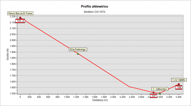
1- along the 108 path leading to Rifugio Benigni and begins in the locality of Sciocc at height 1508 m a.s.l., on the road from Cusio to Piani dell’ Avaro
2- along the 107 path beginning at Ornica and crossing 107A path at 1570 m on the right orographic side of Ornica creek (place Alpeggio Valletto).
Any starting point you take, you get Valletto hut (1625m), here leave the 108 path and follow the 107A path signs. Go left, slightly downhill, getting the basin of Ornica creek and cross it. Following the right orographic side of the creek you get the crossroad with 107 path coming from Ornica. Follow the signs of 107A path that continues nearly flat on the right. After around 300 meters of walk you reach the entrance into lower part of Val Pianella. The path turns sharply westward and climbs steeply in the woods; then staying on the left orographic side of Val Pianella creek, it crosses a more open environment under the south-eastern ridges of Giacomo Peak.
Then, crossed the creek, reach the Nicola hut (1840 m), nearly a ruin but still useful as emergency shelter. The hut is surrounded by several streams flowing into the main course of the nearby creek. Here begins the striking part of the track in Val Pianella. You walk in a morainic basin surrounded by the cliffs Giacomo Peak and Torrione S. Giacomo. In the pastures of the ruined Pastrengo hut you can appreciate the results of the hard work of cleaning the meadows from stones to get more room for the pastures. The path makes a wide turn to bypass some ribs, then crosses some meadows and finally runs near the morainic crests near the slopes of Pascaniello mount. Here the path climbs steeply heading northward in the upper part of the valley (pay attention to small landslides caused by snowfalls). After a hump you get the basin at the top of the valley under the Val Pianella Peak. From here go straight ahead heading northward to Bocchetta di Trona (pass at 2224 m, crossroad of 101 path) to watch Trona valley overhung by the pyramid of Trona peak (2510 mt). On 101 path you can reach, eastward, toward Rifugio Benigni, the crossroad with 108A path, leading you back to the starting point of 107A path
Topografia