Descrizione
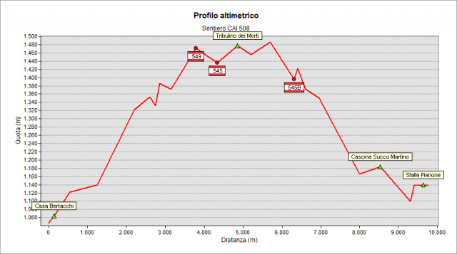
Starting from San Lucio (1027) you pass through a field on your right and you go up into a wood. Walk as far as you find the path’s starting point that corresponds to the forestry road which leads to the Pianone Hut (1142 m.). You pass the plane keeping the right (at the field’s left end, instead, you keep walking on path number 508, but in the opposite way) and you start walking up to get to Forcella Larga (Ilaria’s Hut ruins – 1470). You keep walking on a slight slope on your left and you follow the little road that, in a short time, leads you to Cappelletta dei Morti (The Deads’ little Chapel – 1483 m.). When you get to the saddle between Monte Farno and Montagnina, ignore path n.545 coming down from Campo d’Avene. You keep your left walking up as far as the saddle located between Monte Farno and Montagnina at the height of 1470 m. You go down across the sparse wood as far as a puddle (crossing point with path n.545b). Here you meet a forestry road that you follow up shortly as far as a hut near wide fields (Alpe Fogarolo). Keep on walking down that road (glimpses on Iseo Lake, Bossico’s area and Monte Guglielmo) crossing fields and woods as far as you reach the height of 1166 m. There you take the path on your left, which leads to Cascina Succo Martino (1181 m.). As you pass that mountain house, after a short walk up into the wood, you finally get to Pianone – where the round path ends – and you walk back as far as San Lucio.
translated from the class 2D del corso "Tecnico dei servizi di animazione turistico-sportiva e del tempo libero" di Clusone
Topografia
Documentazione
Note
E' consigliabile percorrere tale percorso ad anello così come è stato descritto, in quanto la segnaletica risulta più chiara. Il verso di percorrenza proposto, inoltre, ha il vantaggio di portare presto nella zona più panoramica, la bella conca del Farno, con la possibilità di salire - facilmente e in poco tempo - sul panoramicissimo Pizzo Formico tramite il tratto terminale del sentiero 549 (dai ruderi della Capanna Ilaria).