Descrizione
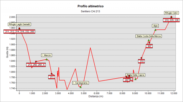
From Rifugio Laghi Gemelli ( Hut) (1961 m) go down toward the Casere lake, cross a bridge and climb quickly to the Marcio Lake, follow its west bank till the dam. Go downhill below the dam and, after some hairpin bends, you reach a ENEL construction for water collecting. There you cross the 211 path, that goes down to Carona. Keep the right path pointing towards a vertical cliff that you will cross without difficulty on a path dug in the rock and on bridges. Going on, you enter the forest and, after passing a small valley, you get the Sardegnana Lake(1735 m). Walk along the dam and climb the wooded coast toward the watcher's house and then climb higher on the path with hairpin bends (up to 1900m). Now the path is nearly flat and passes through the Dosso dei Signori (crossroad with 247path going down to Pagliari), and the “dei Frati” Valley (cross 236 path going up to the Aviasco Pass) Finally you reach a creek. Ford and go up to meet the dirt road coming from Carona and leading quickly to the Fregabolgia Lake. Climb on the top of the dam and follow the comfortable trail, along the lake shore, to Rifugio Calvi (Hut) (2050 m), now in sight.
Topografia
Sentieri collegati
Documentazione
Note
Il bel Lago di Sardegnana svolge l'importante funzione di "bacino di carico" di una decina di laghi posti a quote maggiori: le loro acque vengono convogliate nel lago di Sardegnana e, da esso, inviate alle turbine della Centrale ENEL di Carona. Per maggiori dettagli vedi: http://www.valbrembanaweb.it/cai_piazza/annuario/2002/centrali/centrali…