Descrizione
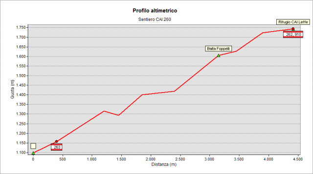
From Gorno village reach Alpe Grina (1115 m) on the paved road following the signs “Rifugi alpini” / “Aree minerarie" (Alpine Huts / Mining areas). Just beyond a plate of prohibition of transit on the left there is a small parking area to leave your car. Follow the road for a short stretch to reach, on the right, the CAI 260 path (overlapped with 263 path – see the signpost).
Climbing shortly, you reach the "Pozza de Fornàs" (pond, at height 1163 m) and then the crossroad where paths 260 and 263 split. According to signpost, climb to the right, reaching in about 15 minutes Forcella Bassa (pass- 30min. after start, 1306 m, signpost) where you turn left getting fast the place called "Garibaldi" (1320), characterized by a ruined hut at the border of the meadow, once shelter for shepherds and herdsmen. Following the path with white-red signs, cross a coniferous wood with nice clears and reach the crossroad to Bivacco Telini (hut, reachable about 20 '). Ignoring the deviation, go straight ahead to reach an area with centuries-old beech trees. Beyond them you find the large pastures of the Baita Foppelli (shepherds’ hut,1608m). At the hut, turn right and reach the ridge, at a pond for livestock drinking (locally called " Posù). Climb leftward, guided by the white-red signs on the grassy pastures heading to Rifugio Baita Golla (managed by CAI section of Leffe -about 2 hours after departure (1756 m)) (winter shelter always open, don’t miss the end-summer party of the hut made every fourth Sunday of September).
If you like to make a round trip to return to starting point, follow the 262 path to Mount Golla (1983 m, 45 minutes from Rifugio): reached the top, go downhill on the south-east ridge to the pond of the Corna hut and, from here, downhill again to Piazza Golla (wide clear with huts). Here leave the 262-path turning right on a the marked path (no number assigned). After a short stretch you reach again “Forcella bassa” pass and the path 260 that takes you back to the starting point. Long, interesting and very panoramic round trip (2:30 h from Baita Golla, 4.30 - 5 h for the whole trip)
Topografia