Descrizione
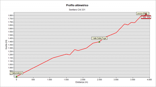
Starting from the garage of “Autolinee SAB” bus lines, placed on the left at the beginning of Valbondione (870 m), climb through the woods towards "Salvasecca" farmhouse. Leave it on the left and continue the ascent until you meet a forest road that you have to follow for a certain distance. The realization of such road has modified, in part, the old route. It is important to pay attention to the white-red signs (especially downhill) to follow the path correctly. Follow it, cross “di Foga” valley (1438 m) and, shortly after, leave it to follow the path on the right, that begins to rise again decidedly. Follow - for a while - the forced pipelines of Dossi hydroelectric power plant (the road leads, instead, to “Stalle di Redorta” stalls). Get out the woods and come to a building provided of many antennas, at an altitude of 1680 m. Continue on the mountainside now, under steep walls and, after a stairway, you reach “il Pozzo” ENEL (a strange construction, a water collection system, 1800 m). Just beyond you cross path n° 330, so joining a “low variant” stretch of “Sentiero delle Orobie Centro-Orientali” (Central-Eastern Orobie Trail) while, just above, path n° 334 begins. Such path ascends first to “d’Avert" lake and then until to cross path n° 302 (the “high variant” stretch of “Sentiero delle Orobie Centro-Orientali” / Central-Eastern Orobie Trail) near “Ol Simàl” (2712 m), the highest point of “Sentiero delle Orobie Centro-Orientali” / Central-Eastern Orobie Trail.
Topografia