Descrizione
CENTRAL-EASTERN OROBIE TRAIL / SENTIERO DELLE OROBIE CENTRO-ORIENTALI
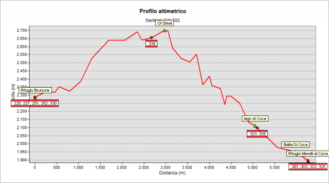
Starting from the “Baroni al Brunone” Refuge (2295 m), proceed toward east by a fairly flat trail, first leaving on the right the path n° 330 (the “lower path” variant of the Orobie Trail) and then, shortly after, on the left the trail n° 252 (towards Redorta Peak). Now you start to climb toward the walls of Redorta Peak (despite this mountainside seems to be inaccessible). The track climbs a steep scree with hairpin bends and cross it in the top right corner, along a rocky ledge, until climb up an easy notch, leading into the high cirque of “dei Secreti” glacier. Cross it and go up to the “dei Secreti” saddle, and then down on the other side. After a flat stretch (on the right the path n° 334 goes down) you climb up to a pass called "Ol SIMÀL" (2712 m), the highest point of the entire Orobie Trail / Sentiero delle Orobie. Now go down a steep unstable gully, cross the head of the “di Foga” valley and continue toward east until the “Forcellino” notch. On the other side, the track goes down a rocky gully and then descends a hard slope made of gravel and grass. With a series of ups and downs and bolted stretches it will come out, high above the basin of “di Coca” lake. Go down to the lake (2108 m) and soon, along the valley, you reach the Coca Refuge (1892 m).
Topografia