Descrizione
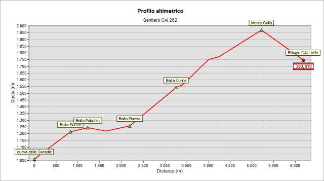
From Ponte Nossa follow the directions to Premolo (road SP 47). Reached the village (end of road SP 47), go straight taking Valzella Street and, at its end, Dell'Agro Street and then Bratte Street leading to the hamlet with the same name. Here you find a plate with the area map, the drinking water fountain and the crossroad with 245 path to Nossana Valley. Follow the paved road by car (Sonfaet Street) for about one kilometer to its end; at right, there is a small parking area. Here begins the private "Belloro" road (830 m) used by authorized herdsmen and farmers. The CAI 262 trail starts here (see signpost and signs on the ground).
Climb on the paved road at the beginning in the woods, and then among well-groomed lawns. Enjoy the wonderful views, especially on the Presolana peak. After about 1.10 h of walk, (3 km walked, and 300 m climbed), you reach the crossroad to Rifugio G.A.E.N. (Hut managed by the hiking group of Ponte Nossa). Go straight on the paved road to the ancient “Palazzo Caino” hut (1240 m).
In this area you find some interesting boards (made by Premolo municipality) explaining the main features of the crossed places.
Just beyond the hut the road reaches the place “Belloro” (1251 m); here the signpost addresses you to go straight on a dirt road (forestal road “Forsei Alti”). At the border of the forest, turn left on the flat path and get the wide pastures of “Piazza Golla” hut (1259 m, signposts, crossroads to Forcella Bassa Pass / Alpe Grina di Gorno and 260 path).
Turn right, on the border of the pasture and then enter the forest again. At the next crossroad climb left, passing near 2 hunting huts (be careful during the hunting season) At the end of the forest you reach an area of lawns with some centuries-old beech trees.
Follow the signs in the lawns to reach a pond for the livestock drinking near Corna Hut (1560 m), (not visible from the path because hidden by a small ridge on the left). Always following the signs, climb up heading the ridge with the Nossana Valley (where Mount Golla has a cliff of about 1000 m). Follow on the left the ridge to the top of Mount Golla (1982 m, about 3 h from the start, 1.15 h from the pond near Corna hut). Please, pay attention in the last part of the walk along the ridge! Wide wonderful panorama from the top,
Go downhill on the left and, always guided by the red-white signs, you reach the Golla Pass (1903 m; if you like, climb, in about 5 minutes, to the top of “Matto di Golla” - 1941 m – follow the grassy rib in front of you). From the Golla Pass, the signpost addresses you to go downhill on the left (on the right the paths 223 and 263 for the Mount Grem) to quickly arrive at the cozy Rifugio Baita Golla(hut managed by CAI section of Leffe) ( 1756 m, 3.30 h from departure, winter shelter always open, don’t miss the end-summer party of the hut made every year on fourth Sunday of September).
If you like to make a round trip to return to starting point, follow the 260 path to Alpe Grina (Gorno) : at Forcella Bassa Pass (1306 m) leave the 260 path and turn left on the linking path (see signs) that will quickly lead you back to Piazza Golla. From here take again the 262 path that leads back to the starting point (2 hours from Rifugio Baita Golla, around 5:30 hours for the whole trip).
Topografia