Descrizione
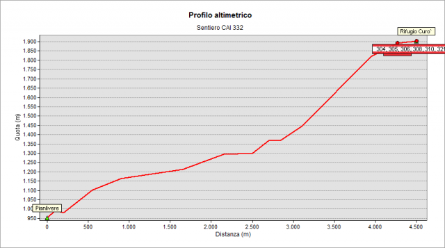
From Pianlivere (970 m – a little hamlet after Valbondione) cross Serio river and go up in the wood - with some hairpin bends – until to reach the pretty Maslana (a little hamlet, ab. 1150 m). Beyond the first group of huts, you arrive at Piccinella place (1192 m), then continue to cross the valley by a stone bridge and pass on the left orographic side. Continue first near the valley bottom and then follow - for a while - a forest road that leads to the Osservatorio Faunistico del Parco delle Orobie (Wildlife Observatory of the Bergamo Alps Park), a characteristic building leaning against a cyclopean boulder. Then you enter a beautiful beech forest and reach the steep meadows located under the rocky belt that bars the valley. By a very steep path, you can hardly gain altitude following the maximum slope line and - by numerous zig-zag – you touch the aforementioned rocky belt. Cross its base eastwards and continue the climb (there is a stretch equipped with chains and metal cables, but it is not necessary use them with dry soil), until to get to Consoli - U.E.B. Hut and to the nearby Curò Hut (1995 m).
Topografia