Descrizione
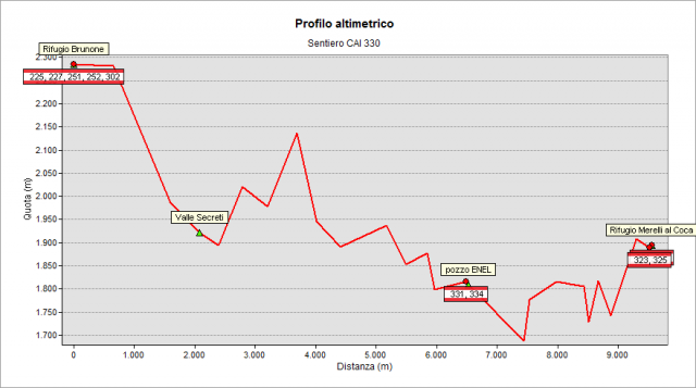
Starting from Brunone Hut (2295 m) follow path n° 302 for a few minutes, then turn right and lose altitude. Cross the “dei Secreti” valley and continue the climb to reach a col at an altitude of 2002 m and - after another stretch along the mountainside - you finally face the Seriana valley at “della Giraffa” Col (2125 m). Continue along the ruins of Ecla farm (1900 m) and Cavallo Col (1930 m), to arrive at the intersection with path n° 334 and path n° 331 at “il Pozzo” ENEL (a strange construction - a water collection system - 1800 m: here arrive all the collection channels feeding the forced pipeline that goes down to the “dei Dossi” hydroelectric power plant). Continue along the mountainside – through the meadows placed at the base of “Pizzo Castello” peak until to reach a stretch dug into the wall (equipped by a chain) that has been reopened and secured in spring 2017 (such section had been closed for some years, obliging a detour). The path – yet aerial and along the mountainside - leads below “Merelli al Coca” Hut (1892 m) which is finally reached by a last short climb.
The path up to “il Pozzo” ENEL is not in very good condition, the works carried out in previous years have been destroyed by the weather and many sections seem more like a track than a path. In the section between “Il Pozzo” ENEL and “Merelli al Coca” Hut, extraordinary works were done (year 2017) to restore the sloping stretches. It is a very special path, it must not underestimated because it runs through a very wild environment and its being so verdant can mislead about the steepness of many points.
Topografia
Sentieri collegati
Documentazione
Note
The section slid down in 2011 at the base of “Pizzo Castello” peak was again dug in the rocky wall and made safe. It is viable from spring 2017 and it allows you to follow the original route again, (the detour that allowed to get around the landslide is no longer maintained). It is a very special path, it must not underestimated because it is in a very wild environment and its being so verdant can mislead about the steepness of many points.