Descrizione
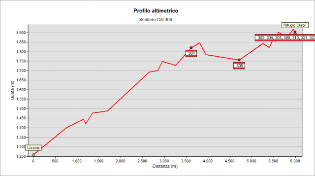
The path starts from the Lizzola church (1250 m approximately), goes up a few meters along a small road, cross the meadows and reaches the woods just above the village. It now continues in the dense fir forest with constant climb to an altitude of about 1650 m. After that, the trail continues - always along the hillside - through steep meadows and shrubs until crossing path n° 304 (at 1800 m a.s.l. about) which comes from “delle Miniere” Col. Follow it, losing in altitude and crossing some gullys (taking a little care and attention!) where they were placed some safety artifacts to facilitate your walk, until reaching path n° 305, rising from Valbondione. The track is now shared by the two paths, along the panoramic stretch hewn out of the rock face. After that, you arrive to Curò Refuge (1915 m).
Topografia
Sentieri collegati
Documentazione
Note
La salita al rifugio Curò da Lizzola potrebbe sembrare sulla carta più veloce e agevole rispetto a quella da Valbondione. In realtà, nonostante il dislivello minore, la salita lungo il sentiero da Lizzola risulta di durata simile a quella da Valbondione a causa dei saliscendi e del tipo di fondo in alcuni tratti un po' sconnesso. Anzi: per i meno allenati risulterà decisamente più facile e veloce salire da Valbondione in quanto la salita è sempre regolare, senza tratti di grande pendenza e con fondo in buono stato.