Descrizione
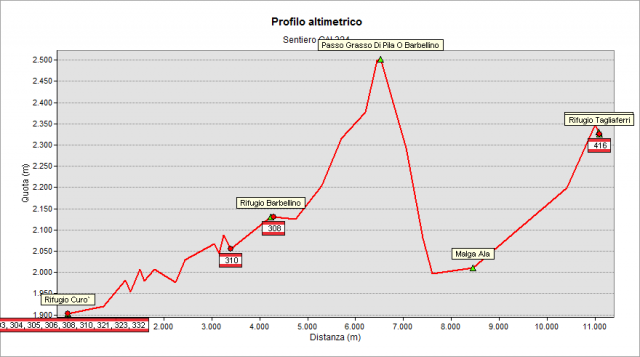
Start from Curò Hut (1895 m), follow the easy muletrack and reach Barbellino natural lake (2188 m). Along the left bank (north) of the lake, climb along Serio river then, at an altitude of about 2300 m, the path curves to the right (east) pointing to the wide saddle of “Grasso di Pila” Pass (also called Barbellino Pass). Going up, you go along the pretty "di Pila" ponds (ab. 2350 m), finally reaching the pass. Then go down the Valtellina side, first in a small basin and then enter a steep grassy canyon, until to a height of 1998 m where you cross a flat path that must be followed to the right (following it to the left, instead, you would reach Valtellina’s Verde lake and Nero lake, located NE of Mount Torena). Continuing on the right (south) - as we said above - you reach soon “Malga di Pila” shepherd’s hut. Then continue to climb the head of Belviso valley and reach “di Venano” Pass (2335 m), thus returning to the Bergamo side of the watershed. Tagliaferri Hut (2328 m) is a few meters beyond the pass.
Topografia
Sentieri collegati
Documentazione
Note
Alla testata della val di Belviso - parzialmente percorsa ad occidente dal sent. 324 - si possono notare nelle Mappe il "Grasso di Pila" (attorno alla Malga di Pila) e, dirimpetto a oriente di essa, il "Grasso dei Batai": l'origine della parte comune "Grasso" deriva da "Gras" o "Grasèi": luogo fertile e ben concimato dalle bestie che vi sostavano frequentemente e lo... "ingrassavano" (concimavano).